Quest for corals: unveiling the anatomy of a scientific expedition to Bonaire

Quest for corals: unveiling the anatomy of a scientific expedition to Bonaire

In March 2023, while tourists were enjoying the wondrous coral reefs of Bonaire and the commodities of its capital, Kralendijk, five scientists from the Paleontology department of Freie Universität Berlin landed at Flamingo International Airport with over 100 kg of diving and scientific gear. Their goal was to collect coral samples and use the information archived in their skeletons to unravel past disturbances and stressors in the Bonairean coral reefs.

However, this adventure started long before that, with an odyssey to secure all the essential permits and equipment. In some cases, it actually meant engineering instruments to facilitate proper sample collection, such as stainless-steel drill bars and a frame used to aid the drilling process.

This frame facilitates drilling perpendicularly to the main growth axis of the corals – a crucial step to assess their growth density bands. In addition, it constrains drifts from the drill on the topmost surface of the coral, particularly common at the beginning of the drilling process, which can cause significant tissue damages. After months of thinking, elaboration, and eventually a leap of faith, the frame construction was a great success for which we must greatly thank Detlef Müller, his team from the Physics department at the Freie Universität Berlin, as well as Benjamin Rommel, from the Geology department at the Freie Universität Berlin.

On the 6th of March, with everything ready, we crossed the Atlantic Ocean and finally landed on Bonaire. At this point, it is a common misconception that scientific field work is a romantic combination of breath-taking dives intercut by naps under palm trees on the beach and immersion into the local culture. While there was some of that, the reality was quite different – certainly not because of Bonaire’s wonderful beaches which, interestingly, can have more coral rubble than white sand.

In fact, everyday would start at 6 o’clock, divers would be in the water by 8:30 the latest, and the days would be full of activities until 10 pm – so there was not much room for naps on the beach. Still, all the amazing dives and a couple of days off gave us the energy and motivation to keep accomplishing our goals.

The first challenge in the field was to find the coral chosen for the study – the coral Siderastrea siderea. It is a main reef-building species in the Atlantic reefs that produces seasonal growth bands (visible under X-rays), is long-lived (up to a few centuries) and stress-tolerant. However, during our recognition dives, we witnessed the spread of the Stony-Coral Tissue-Loss Disease (SCTLD), a new disease to the island that is severely impacting corals in the Caribbean since 2016. Filtering out those areas affected by the presence of SCTLD increased the challenge to find appropriate colonies of S. siderea.

Luckily, S. siderea corals were not affected by SCTLD, and we were able to determine relevant sampling sites based on their exposure to human impacts. The next step was to select a sufficient number of colonies, which should ideally be large enough to provide several decades of growth records. Additionally, they should appear healthy, so that biases associated with individual performance are avoided, and be isolated from other organisms, as it diminishes the chances of accidentally touching other organisms. After the coral colonies of interest were selected, the next step was to successfully retrieve cores from them.

This process proved to be challenging as the air supply was based on diving tanks – and our friend “Drill” can breath a lot! To provide air supply for the drill, snorkelling buddies replaced empty tank bottles on the surface while divers drilled and collected the coral cores underwater. The divers needed to find the correct angle for drilling, collect the core from inside of the colony, fit a cement plug into the hole left by the core, and bring the samples safely to the boat/coast. There, tissue samples were immediately collected for genetic analyses and cores were catalogued. The support of boats and their crew members allowed us to access more distant sites and improved our sampling effort, despite a limited number of days. All this effort could not have been possible without the invaluable support of STINAPA and its staff, as well as Charlie.

The cores were dried, labelled, stored, and transported back to Berlin. Their density growth bands will be identified with use of Computerised Tomography (CT) scans and X-rays, in collaboration with the Leibniz-Institut für Zoo- und Wildtierforschung (IZW) in Berlin and the Universität Leipzig. The annual growth rates of these corals may reveal temporal trends and associations with environmental changes documented over the past decades. The geochemical composition of their skeletons (i.e., trace element concentrations) will also be assessed, and may assist in the identification of chronic or episodic stressors potentially impacting these reefs. This information will contribute to conservation and management strategies aimed at protecting, conserving, and restoring these unique ecosystems.

Share this post

Unlocking the potential of Nature-based Solutions in marine and coastal environments: The MaCoBioS Blue NBS Toolbox has launched!

Unlocking the potential of Nature-based Solutions in marine and coastal environments: The MaCoBioS Blue NBS Toolbox has launched!

The MaCoBioS Blue Nature-based Solutions Toolbox is now available on our website! 

In recent years, Nature-based Solutions (NBS) have gained attention as a cost-effective and sustainable approach for addressing diverse societal challenges, including biodiversity loss and the impacts of climate change. NBS have shown great potential in terrestrial and urban settings. However, progress has been slower when it comes to using them in marine and coastal environments (what we call ‘blue NBS’). This is mainly due to a lack of tools and resources to help decision-makers and practitioners implement these solutions effectively. 

To fix this, we introduce the MaCoBioS Blue NbS Toolbox, a collection of multidisciplinary tools and products to help inform the design and implementation of interventions in marine and coastal environments.

What’s inside the MaCoBioS Blue NBS Toolbox?

The MaCoBioS Blue NBS Toolbox integrates a portfolio of evidence-based resources, developed with stakeholders, to support practitioners during different implementation stages of blue NBS. It also includes information anticipated to be of interest to non-experts, including those approaching blue NBS from community- or stakeholder-led initiatives, and researchers who may wish to apply or develop the tools presented. 

The aim of this toolbox is to provide tools and information that help answer questions like: ‘What happens to an ecosystem and its services if…?’; ‘Will a community be able to adapt to change and how can we help?’; ‘When, where, and how could we act? 

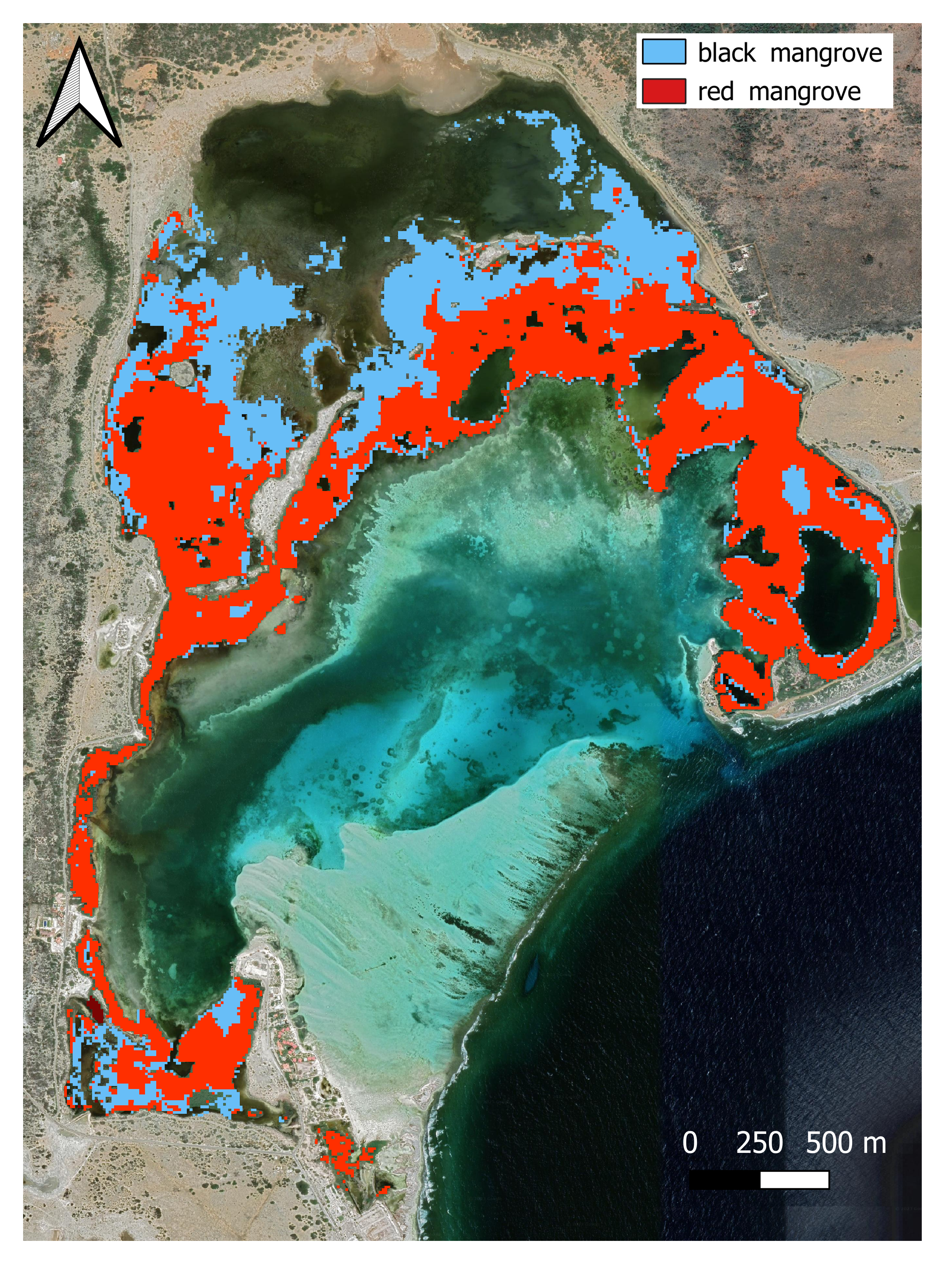
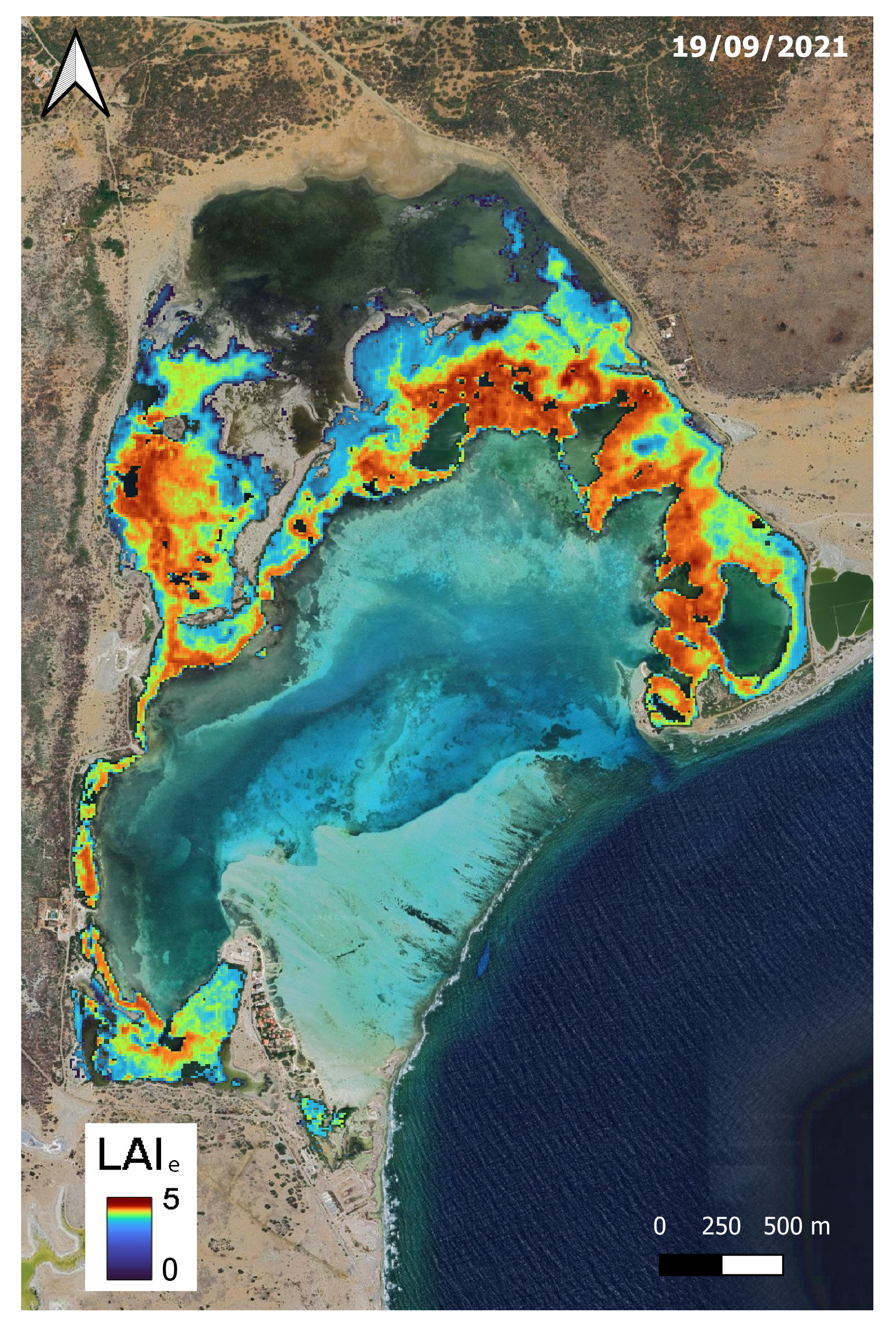
To improve the user’s understanding of the MaCoBioS project and its resources, the toolbox initially showcases six StoryMaps. These StoryMaps shine a spotlight on the work of MaCoBioS in mangrove forests, coral reefs, kelp forests, maërl beds, seagrass beds, and salt marshes. 

The toolbox features five tools for users to explore:

  • MaCoBioS’ Conceptual Models help managers understand and visualise complexity to inform where management might be desired.
  • Coast-Adapt offers guidance on conducting index-based adaptive capacity assessments in coastal social-ecological systems to support decision-making aimed at reducing social vulnerability and enhancing adaptive capacity.
  • MARITIME supports the design of blue NBS by modelling how marine and coastal ecosystems respond to cumulative impacts.
  • MAS-NBS (a Multi-tiered Approach to assess Suitability for NBS) helps identify areas with suitable conditions for implementing blue NBS.
  • PBI-Support (Potential Blue Interventions Support) provides a structured framework to guide decision-makers and practitioners through the initial planning stages of implementing NBS in marine and coastal ecosystems.

The toolbox also provides insights into data collection for biodiversity and ecological condition assessment in different marine and coastal ecosystems. Complementing all these tools and guidance is a WebGIS platform consisting of an Interactive Visualisation Tool that displays the spatial products developed at an ecoregional level.

To accomplish effective blue NBS implementation, all stakeholders involved in, and affected by, the NBS should be included in the design and implementation process. Management must understand the NBS policy and be aware of local community concerns and social pressures.  This helps to create socially acceptable interventions. That’s why, based on information gathered in the MaCoBioS project, the toolbox includes some short policy briefs and guidelines that aim to inform how we move forward with blue NBS in policy, practice, and research. 

Supporting use, collaboration, and effective decision-making

The tools in the MaCoBioS Blue NBS Toolbox were designed to be complementary but can also be used as standalone procedures. Contact details for the main developers of each tool have been provided to make it easy for users to reach out for more information or to explore collaboration opportunities. 

The growing use of blue NBS underlines a pressing need for tools and resources to guide decision-making and management processes. That’s where accessible and user-friendly tools come in – they’re essential for aiding stakeholders in identifying the right interventions that work both ecologically and socially. This toolbox provides a starting point that can guide the design and implementation of effective blue NBS, thereby playing a part in safeguarding marine and coastal social-ecological systems.

These tools were created in collaboration with many stakeholders throughout the four-year MaCoBioS project and a special thank you goes out to all of them for their time and commitment.

The MaCoBioS Blue NBS Toolbox can be accessed here

Share this post

Can small mangrove forests be monitored from space?

Can small mangrove forests be monitored from space?

The decline of mangrove forests worldwide is concerning because these ecosystems offer crucial benefits for both nature and people. They boost biodiversity, shield coastlines, store carbon, and support local fisheries. In the Caribbean, mangroves have suffered in the past twenty years from coastal development, population growth, and climate change. This loss isn’t just about mangrove trees; it has serious consequences for wildlife, the resilience of coastal areas, and the well-being of coastal communities, especially on small islands.

Luckily, technology can help. The use of remote sensing from satellites, for instance, offers a cost-effective way to monitor mangroves over large, inaccessible, and hazardous areas. The Sentinel-2 satellites, run by the European Earth Observation Programme Copernicus, are particularly useful. They provide detailed (10 m spatial resolution) and regular images for free, which is a big help for small islands that might struggle to gather this kind of data otherwise, for example, through field campaigns that are very challenging in mangrove ecosystems.

In a recent study, we used Sentinel-2 data to map mangroves on Bonaire, a small tropical island in the Caribbean. Our findings indicate that NDVI (a traditional vegetation index derived from satellite images) can accurately map the extent of the small mangrove forest in Lac Bay, with optimal results achieved during the dry season. We estimated the extent of the mangrove forest in Lac Bay to be 222.3 hectares, with 136.0 hectares attributed to Rhizophora mangle (red mangroves) and 77.1 hectares to Avicennia germinans (black mangroves). A small portion (~ 9 hectares) remains unclassified, likely dominated by Laguncularia racemosa, although on-site validation is necessary for confirmation. Determining mangrove tree species from satellite images is a great achievement, made possible with tailored ground-truthing to train and validate remote sensing algorithms.

Distribution of the black mangrove
Distribution of the black mangrove A. germinans (in blue) and the red mangrove R. mangle (in red) in Lac Bay derived from the Sentinel-2 image registered on 23/03/2022
Map of estimated Lie for lac bay (Bonaire)
: Maps of estimated LAIe for Lac Bay (Bonaire) for satellite image recorded on 19/09/2021 (dry season).

Furthermore, by measuring on the field the amount of sunlight available above and under the canopy, we were able to derive additional indicators from remote sensing, such as the Leaf Area Index (LAI), an indicator of leaf density, which provides a good insight on the ecological condition of the mangrove and Net Primary Productivity (NPP), an indicator of ecosystem function . The latter corresponds to the difference between the amount of carbon absorbed during photosynthesis and the amount of carbon released during respiration. With a mean NPP rate of 8.82 ± 1.46 gC m-2 d-1, which is equivalent to about 140 tonnes of atmospheric CO2 absorbed per hectare and year, the mangrove forest of Lac Bay in Bonaire absorbs about 26 260 tonnes of CO2 per year. By absorbing the atmospheric carbon, the mangroves of Bonaire contribute to regulate our climate.

In summary, this study offers a practical and affordable way to watch mangroves, not just in Bonaire but potentially on similar small islands facing similar challenges. This kind of monitoring is vital for making informed decisions about how to safeguard these valuable ecosystems, especially in places where resources and expertise are limited. As we are facing climate change, every contribution counts, that’s why we need to monitor closely the state of mangrove forests to be able to address any future changes accordingly, by protective measures, restorative action, or other management measures.

You can read the full article here.

Text by Gema Casal Ewan Trégarot, Cindy Cornet


Share this post

Cladocora caespitosa: a temperate coral growing in a climate change hotspot

Cladocora caespitosa: a temperate coral growing in a climate change hotspot

The Mediterranean Sea is often referred to as a “climate change hotspot”. For people living around the Mediterranean basin, this is becoming increasingly obvious as storms become more violent and frequent, droughts become the new norm and crushing summer heat waves hit new records every year. But in the midst of these events, it might be easy to forget that the Mediterranean marine environment is just as vulnerable as its terrestrial counterpart. Indeed, with temperatures increasing three times faster than the rest of the globe, the Mediterranean Sea is prone to a topicalisation process that facilitates the settlement of potentially invasive tropical species and is responsible for extensive mortality events in benthic communities. As a result, irreversible shifts in species distribution are occurring, changing the composition of communities and their dynamics.  

 Cladocora caespitosa (commonly known as cushion coral) is a temperate coral endemic to the Mediterranean, and a good example of a species impacted by such climatic events. As the only coral in the region with the potential to build reefs, it is a key bioengineering species for Mediterranean benthic ecosystems, providing habitat and shelter to many species of algae, polychaete, crustaceans, sponges, and more. While it is more common during a dive to find a handful of football-sized colonies of this coral spread on the bottom, it is still possible to find places around the Mediterranean with extensive reef-like formations.

Colonies of Cladocora caespitosa growing in the Montgrí Natural Parc (Catalonia, Spain). The picture on the left shows a colony with partial mortality, while picture on the right shows a colony that completely died very recently. Pictures by Marina J. Vergotti

Its limited capacity to spread during reproduction, its slow life dynamic and the recurring mass mortality events affecting this species during the last three decades make it especially vulnerable to environmental stressors, including those linked to climate change. As a result, it has been a part of the IUCN red list of endangered species since 2015 and is protected in a number of Mediterranean countries. This fact has put Cladocora caespitosa at the centre of several research projects focusing on its distribution and long-term responses to increasingly frequent marine heat waves. However, it is still relatively understudied compared to its tropical relatives, and much still needs to be understood regarding the sub-lethal responses of this coral to climate change.

One of the ways corals reflect changes in their environment is by altering their growth patterns, which are recorded in their skeletons. Indeed, just as trees respond to seasonal cycles by depositing a pair of growth rings every year, so do corals by depositing in their skeleton a couple of growth bands of high and low density. These bands can be revealed using methods such as computer-tomography (CT) scanning or X-rays, and used to “go back in time” by reconstructing the coral’s life-history, which can, in turn, help understand changes in their environment. By reconstructing their past growth, it is also possible to extract information about past stress events, such as marine heat waves, that can result in anomalous growth patterns visible in the coral growth bands. 

X-ray of a Cladocora caespitosa fragment showing a mark of stress estimated to have happened during the summer of 2017.

In MaCoBioS, we strive to study how Cladocora caespitosa responds to seawater temperature changes (such as marine heat waves) and seasonal variations of pH. For that, we study coral skeletons from several sites in the northwestern Mediterranean using X-rays to measure their growth bands and analyse how these environmental changes are affecting coral skeletal growth. The coral skeletons are studied further in the lab to analyse their chemical composition and the changes according to the seasons. The goal is to understand better the stress responses of this coral to marine heat waves, by checking for tolerance limits and for resilience patterns. We also want to get a better understanding of how the corals respond to seasonal changes in seawater properties, and how these responses affect this coral’s capacity to withstand stress events. This information is crucial for the development of effective management strategies to protect these species.

Share this post

The effects of climate change on marine coastal ecosystems – what do we know and what can we do?

The effects of climate change on marine coastal ecosystems – what do we know and what can we do?

Climate models predict substantial transformations in the state of our oceans over the next century, bringing about significant impacts on the entire Earth system. These changes will have far-reaching consequences for marine biodiversity and human well-being. Globally, coral reefs, kelp and mangrove forests, salt marshes, seagrass beds and other bio-engineers rank among the most vulnerable marine and coastal ecosystems to climate change. In addition to global changes, the impact of local human activities on these ecosystems is profound. These local stressors can significantly reduce the resilience of these ecosystems and influence their ability to withstand the effects of climate change, i.e., their capacity to cope with heavy perturbations, such as a heat wave or a hurricane.

While climate change cannot be locally managed or contained, local stressors can be. It is therefore crucial to understand which of these stressors need to be managed to increase the resilience of marine and coastal ecosystems to climate change’s impacts. Furthermore, did you know that marine and coastal ecosystems are some of the bests at sequestering atmospheric carbon or protecting our coastline from erosion and sea level rise? As such, taking local actions to foster the good health of these natural environments not only favours their functioning and resilience but also plays a vital role in mitigating and adapting to climate change. 

We brought together a team of 20 scientists and engaged in a momentous collaborative effort to identify and synthesise current information on how climate change and local stressors together affect marine and coastal ecosystems. The review focuses on six of these ecosystems that are predominant in Europe and its Overseas Territories, covering three ecoregions of focus in the project: Northern European kelp forests, salt marshes and seagrass beds; Mediterranean corals Cladocora caespitosa, maërl beds and seagrass beds; and Caribbean coral reefs, mangrove forests and seagrass beds.

Environmental tipping points and safe operating spaces

Tipping points are understood as the point where, following a perturbation, a self-propagated change can eventually cause a system to shift to a qualitatively different state. A safe operating space, then, is understood as the range of environmental conditions that lies between tipping points for which the functioning of the ecosystem remains stable.

Adapted from Selkoe et al., 2005. Credit: MaCoBioS.

The review we conducted presents the climate change stressors, such as warming, extreme weather events, ocean acidification, or sea level rise and how they affect our focus ecosystems at different levels, from their metabolism and reproduction to their survival and distribution. More particularly we were interested in identifying potential thresholds above which the ecosystems are severely impacted, such as for instance, the water temperature above which kelp forest dies (23°C for Laminaria digitata and L. hyperborea) or stop their growth and reproduction (18°C) depending on the development stage. However, experiment size, costs, and project time constraints are among the main limitations to investigating these thresholds, making it difficult to establish when a tipping point for an environmental factor is precisely reached for many ecosystems.

What about the combined effects of direct local human pressures?

The complex interactions between climate change drivers and local stressors further affects where these environmental thresholds are located, making it increasingly challenging to identify them. However, our review allowed us to highlight local stressors that further increase the vulnerability of marine and coastal ecosystems to the effects of climate change, as well as some overall cumulative effects of local and climate change stressors on these ecosystems. For instance, studies on the interactive effects of climate change and local stressors on coral reefs have intensely focused on warming, terrestrial run-off, and grazing. More particularly, nutrient enrichment resulting from coastal run-off acts in synergy with increased temperatures to favour shifts to algal-dominated communities and promote coral diseases.

Disentangling the combined effects of multiple stressors is extremely difficult, especially when considering that the response of the ecosystems studied is also often specific to a species, and for the same species, the response can further vary between populations and individuals, depending on environmental factors, genetics, etc. As a result, of all these variability factors, there are still many unknowns when it comes to identifying thresholds. 

Where do we go from there?

Without devaluing the urgency to drastically reduce greenhouse gas emissions into the atmosphere (cf. COP1 to 28), we need to prioritise local actions to relieve some of the anthropogenic pressures acting on marine and coastal ecosystems to help them thrive under climate change. Going back to the coral reefs example above, having a watershed approach to addressing nutrient enrichment through, for instance, better wastewater treatment and reduced use of fertilizer in agriculture, would alleviate this pressure on coral reefs and allow them to better cope with temperature increases. Furthermore, as coral reefs, seagrass beds and mangrove forests are often connected, supporting each other, any conservation action implemented for one ecosystem will most likely benefit the other ecosystems as well.

There will always be knowledge gaps and uncertainty around the potential cumulative impacts from climate change-related and local stressors. One thing we know for sure is that we must act now and effectively to reduce the local pressures that are manageable, whilst climate change should be addressed both locally and globally by cutting the emissions of greenhouse gases.  

The full paper can be found here: https://doi.org/10.1016/j.biocon.2023.110394


Text by Ewan Trégarot, Silvia de Juan, Kieran Deane and Cindy Cornet

Share this post

Sharing 40 years’ experience of working on mangroves – the generous forests of the tidal zone

Sharing 40 years’ experience of working on mangroves – the generous forests of the tidal zone

Discovering mangroves

My enthusiasm for mangrove ecology started in a long house in the Gulf Province in Papua New Guinea. This huge structure was made entirely of mangrove timbers and thatched with fronds of a mangrove palm. Here I listened as my colleague in the Office of Forests negotiated with the traditional land owners for permission to conduct fieldwork. Young men from the village were detailed to observe and assist our team that was to weigh a huge tree within the forest. That sweaty teamwork was my introduction to the idea of biomass – the weight of living matter within a forest. I wondered what the young men would tell the village elders about our activities, but was hooked on mangrove forests after that!

Mangroves are trees that live in tropical tidal waters, where the salt and daily submergence prevents establishment of almost all other trees. Confusingly, but understandably, people also refer to forests of these trees as mangroves. In the last quarter of last century, a large portion of mangrove forest cover was lost due to conversion of these areas for aquaculture of prawns and fish. Encouragingly, in the current century, the value of mangrove forests has come to be more widely appreciated and mangrove loss has slowed with some areas of forest being re-established.

Celebrating the importance of mangroves

Mangrove forests are a vital part of the carbon cycle that buffers us from climate change.  They draw down carbon dioxide from the atmosphere and store the carbon in the leaves, branches and trunks of the trees, but as leaves and woody parts of the trees are shed leaves, carbon is transferred to in the sediment in which they grow and into coastal waters. Remarkably these forests can contain as much carbon in the trees as in rainforests do, but they store much more carbon than rainforest do locked up in the soil in which they grow. Plant waste travelling out on the tides supplies food to coastal waters. The forests also act as nurseries for fish and prawns that are caught in waters offshore. Juvenile fish feed and develop among the protection of roots and move into offshore when able to fend for themselves. Some, such as groupers, move to coral reefs. Mangrove roots stabilise shore sediments and also break up inrushing waves.

The underwater life associated with mangroves – Bonaire Credit : Ewan Trégarot

Mangroves and the work of MaCoBioS

Mangroves range from the northern end of the Red Sea to the North Island of New Zealand and flourish on calm subtropical and tropical shorelines in between. Surf shores are not suitable for mangroves. Though mainly located in the waters of continental Europe, the MaCoBioS project extends into the Caribbean with particular case study sites in Bonaire, Martinique and Barbados, where mangroves play an important role in protecting and feeding juvenile reef fish. In the Caribbean, mangrove forests survive cyclones while protecting the shorelines. Scars of hurricane track are visible in these forests many years after the event. Though much smaller in height and area covered than the huge forests of the Gulf of Papua, these Caribbean forests serve the island communities in numerous ways. They are particularly closely linked with the health of nearby coral reefs, act as key stepping stones for migrating birds, are recreational areas and also destinations for ecotourists. The challenge is to ensure the future supply of these ecosystem services, by taking account of the needs of this generous ecosystem in coastal zone planning.

Strong connection with associated ecosystems such as seagrass beds and coral reefs – Bonaire Credit : Ewan Trégarot

One of the pleasures of working with mangrove ecosystems is that those who do are natural collaborators who are committed to the cause of protecting these ecosystems. I hand over here to Ewan Trégarot to talk about the mangrove component of the MaCoBioS project.

Our experts are studying what are the effects of climate changes and anthropogenic stressors on mangroves and how those multiple pressures interact with each other’s. How can we use remote sensing to monitor the ecological condition of mangroves and the ecosystem services provided? What would happen to mangroves in the Caribbean in 2050 or 2100 given the current climate change predictions? Many questions remained to be answered, and hopefully, interesting elements of response will come up soon. Accordingly, remedial work will be recommended to foster the return of mangroves through replanting, restoring tidal circulation and minimising undesirable threats from urbanisation. There need be no losers if remedies are well planned.  

The generous forest of the tidal zone – Martinique Credit Ewan Trégarot

Share this post

Why are kelp forest important ?

Why are kelp forest important ?

Kelp forests and their importance for nature and society

Kelp forests are often regarded as “underwater rainforests”. Formed by the dense growth of several kelp species, they produce a three-dimensional habitat and a highly productive system. Usually found in water temperatures below 20 °C, kelps are large brown algae that attach to the seafloor (‘benthic’). Not only can kelps grow amazingly fast in the right conditions – up to 30 cm per day – they can also reach 45 m long for the giant kelp. As well as providing plenty of surfaces and nooks and crannies for other species to settle on or in and live, they shelter coastlines from storms and help sequester or absorb carbon from the atmosphere, making them incredibly important societal resources.

Laminaria hyperborea kelp, Norway

Kelps as important biodiversity and feeding grounds

The forests created by kelps provide a home for a huge variety of different species, from other benthic algae to invertebrates, fish and marine mammals. Investigations along the Norwegian coast have shown a maximum of almost 100 000 small invertebrates connected to one single stipe (main stem) of the species Laminaria hyperborea. With on average 10 plants per m2, this makes up a very high diversity and abundance of animals which form the base of food webs up to fish and mammals. Many of these fish are then caught for food by humans.

The three-dimensional habitat of kelp forests also provides shelter for many species and make great places to hide from possible enemies. The holdfasts of kelps anchor them to the seafloor, and their branched root-like structure means several different species use these as habitat. For example, the edible crab (Cancer pagurus) usually lives inside this holdfast when it is young, protected from predators. You will often see a large holdfast housing many species of worms, brittle stars, molluscs, and crustaceans. The stipe and the fronds (leaf-like structures) of kelps provide additional types of habitats to different species. Usually overgrown by epiphytes – algae and animals that grow on a plant – up to 50 or 60 different species of algae, consisting of mostly red algae, can be found on any one stipe. These epiphytes provide an additional dimension to the kelp forest and, in turn, support many other animals with shelter, food and raw materials. For instance, many smaller crustaceans, such as the shrimp-like amphipods, use these algae as a substrate to build the small tubes they live in.

Brittle stars in a kelp holdfast, Norway

Kelps also provide valuable spawning and nursery grounds for numerous species of fish and shellfish, which go on as adults to become the foundation for many commercial and recreational fisheries, such as the Atlantic cod, Gadus morhua. These smaller fish then attract larger predators like seals, sharks, and sea birds who hunt around the kelp canopies.

Threats and changes to kelp forests

Globally, kelp forests are increasingly threatened by a variety of human impacts, including climate change and fishing/hunting, harvesting, eutrophication.

Being a cold-water species, kelp forests are sensitive to elevated temperatures. As ocean temperatures increase as a result of greenhouse gas emissions, massive kelp forest die-offs are increasingly likely, with their return questionable. In some places, such as in Australia and Tasmania, we have already seen that kelps have not returned to areas they were once abundant.

Fishing through kelp forests using destructive methods like bottom trawling has also been implicated in dramatic declines of kelps, such as in the UK, while predator removal from fishing/hunting has likely changed ecosystem structure in many kelp forests. Few large animals graze on fresh kelps except for sea urchins; however, these animals can devastate a kelp forest, grazing until only denuded rocks, or barren grounds, are left. When urchins are removed, vegetation often rapidly returns, although the animals take longer. The reason for this overgrazing is still under debate but, in most cases, it is probably caused by predator removal leading to an increase in urchin populations. The most well-known example of this comes from the west coast of Canada and the United States, where sea otters were extensively hunted. As their population declined, urchin populations increased and grazed down the kelp forest. After the hunting of otters was stopped, the kelp forest returned.

Sea urchins (Strongylocentrotus droebachiensis) grazing kelp forest in Northern Norway.

Kelps in our daily lives

Kelps are more important to our daily lives than you might think. In particular, they produce alginates to allow their flexible branches to withstand the constant movement from waves. This substance is widely used in pharmaceutical products, like pill coatings or toothpaste, and food production, including ice cream or beer.

The role of kelp forests in climate regulation

Marine macroalgae, such as kelps, play an important role in reducing the effects of climate change. Like plants on land, kelps photosynthesise to grow, absorbing carbon dioxide in the process. Globally, marine macroalgae may sequester around 170 million tonnes per year (range 61-268 tonnes C year−1, Krause-Jensen & Duarte, 2016), equivalent to more than 600 million tonnes of CO2 or 2% of global emissions annually. Healthy kelp grows fast and exports much of its biomass, via frond shedding, to the deep sea. Because deep-sea sediments have little direct contact with human activities, this “blue carbon” is trapped and stored for centuries.

While there will be no substitute for rapid reductions in greenhouse gas emissions to mitigate climate change, kelp forests provide a valuable addition to the arsenal of tools for reducing its effects. Therefore, understanding the impact changing environmental conditions will have on kelp itself is key to predicting future changes in its distribution and functions, including its blue carbon role. In particular, within MaCoBioS, we focus on exploring the evidence for ‘tipping points’ for different kelp species in Europe and developing models to predict future changes and identify potential management options, including Nature-Based Solutions, to mitigate the further loss of kelp forests.

References

Krause-Jensen, D., & Duarte, C. M. (2016). Substantial role of macroalgae in marine carbon sequestration. Nature Geoscience, 9(10), 737-742.

Share this post

Mapping Marine Ecosystems

Mapping Marine Ecosystems

Why do we need to map the ocean?

The ocean is essential for all aspects of human well-being and livelihoods. Marine ecosystems provide food, moderate the climate, protect the coast and provide countless opportunities for recreation and cultural experiences. But the living conditions and resources in the enormous water masses of the ocean remain largely unknown and unmapped. 

It is a well-known fact that we know more about the surface of the moon than we do about the seafloor. For example, we know that on average the ocean is 3 km deep, but this doesn’t account for outliers like the Mariana Trench, which stretches to depths of 11 km. So, if we don’t even know the exact volume of the oceans, how can we manage them fairly and sustainably? There are many issues that must be addressed to fully understand and protect the oceans for future generations and maps are fundamental tools to advance research in this regard.

Although the ocean is vast, marine life is not uniformly distributed within it, and some ecosystems are more biologically rich than others. Coastal ecosystems generally contain more oxygen and nutrients and are warmer and sunlit. Thus, they are more diverse than open ocean ecosystems. Understanding and being able to visually represent these differences using mapping techniques is essential to monitor and properly manage marine ecosystems. Without this information we risk depleting vital resources and causing irreversible damage.

How do we map marine ecosystems?

The traditional and most commonly used sources of information to create maps of marine ecosystems are in-situ measurements, taken directly from the area of interest. Depending on the accessibility of the area, the logistical and equipment requirements can range from a pair of boots to SCUBA diving gear and even include oceanographic vessels, if mapping occurs in open ocean.

Another way of obtaining information that allows us to map marine ecosystems are remote sensing techniques, through satellite observations, for example. These techniques, in combination with traditional methods, have significantly contributed to updating navigational charts with coastline and bathymetric data, to mapping the distribution and types of coastal ecosystems and to monitoring the condition of coral reefs, amongst others.

In some cases, direct detection of ecosystems or species is not feasible with remote sensing techniques, for example due to depth or turbidity. Instead, indirect detection may be possible by observation and modelling of associated sea surface phenomena. For example, changes in ocean colour from blue to green may serve as an indicator of increasing plankton abundance. The green colour is associated with the presence of chlorophyll; the light retaining phytoplankton pigments. Water temperature is another important factor in determining ecosystems and species distribution. Thermal sensors can be used to produce maps of the sea surface temperature, which can be used to identify different water masses and draw boundaries among them.

Credits: Afonso Prestes, 2021

Beyond biophysical techniques

Both in-situ and remote sensing observations are techniques that provide information to map marine ecosystems from a biophysical perspective, i.e., based on biological, physical and chemical features, but they can also be mapped from a social perspective. Highly relevant maps based on human perceptions and socioeconomic knowledge on marine ecosystems can be produced for monitoring and management purposes. As an example, this link gives access to a publication on ecosystem services mapping in the Azores Archipelago, led by our partners from Fundação Gaspar Frutuoso (FGF). Despite not being a MaCoBioS case study area, the FGF team is developing complementary work in this European Union Outermost Region from Portugal, because its natural and social contexts and specificities make it a very interesting hotspot to study and map socio-ecological relationships in the coastal/marine environment.

Furthermore, along with Maynooth University (Ireland), the FGF team is supporting all the MaCoBioS partners in terms of remote sensing data prospecting, processing and analysis, to fill existing gaps in the characterization, assessment and monitoring of the project’s case study areas. The FGF will also set up the MaCoBioS WebGIS platform, an online tool with geospatial capabilities for partners, stakeholders and the general public to visualize and analyse the georeferenced project’s outputs.

Share this post