The decline of mangrove forests worldwide is concerning because these ecosystems offer crucial benefits for both nature and people. They boost biodiversity, shield coastlines, store carbon, and support local fisheries. In the Caribbean, mangroves have suffered in the past twenty years from coastal development, population growth, and climate change. This loss isn’t just about mangrove trees; it has serious consequences for wildlife, the resilience of coastal areas, and the well-being of coastal communities, especially on small islands.
Luckily, technology can help. The use of remote sensing from satellites, for instance, offers a cost-effective way to monitor mangroves over large, inaccessible, and hazardous areas. The Sentinel-2 satellites, run by the European Earth Observation Programme Copernicus, are particularly useful. They provide detailed (10 m spatial resolution) and regular images for free, which is a big help for small islands that might struggle to gather this kind of data otherwise, for example, through field campaigns that are very challenging in mangrove ecosystems.
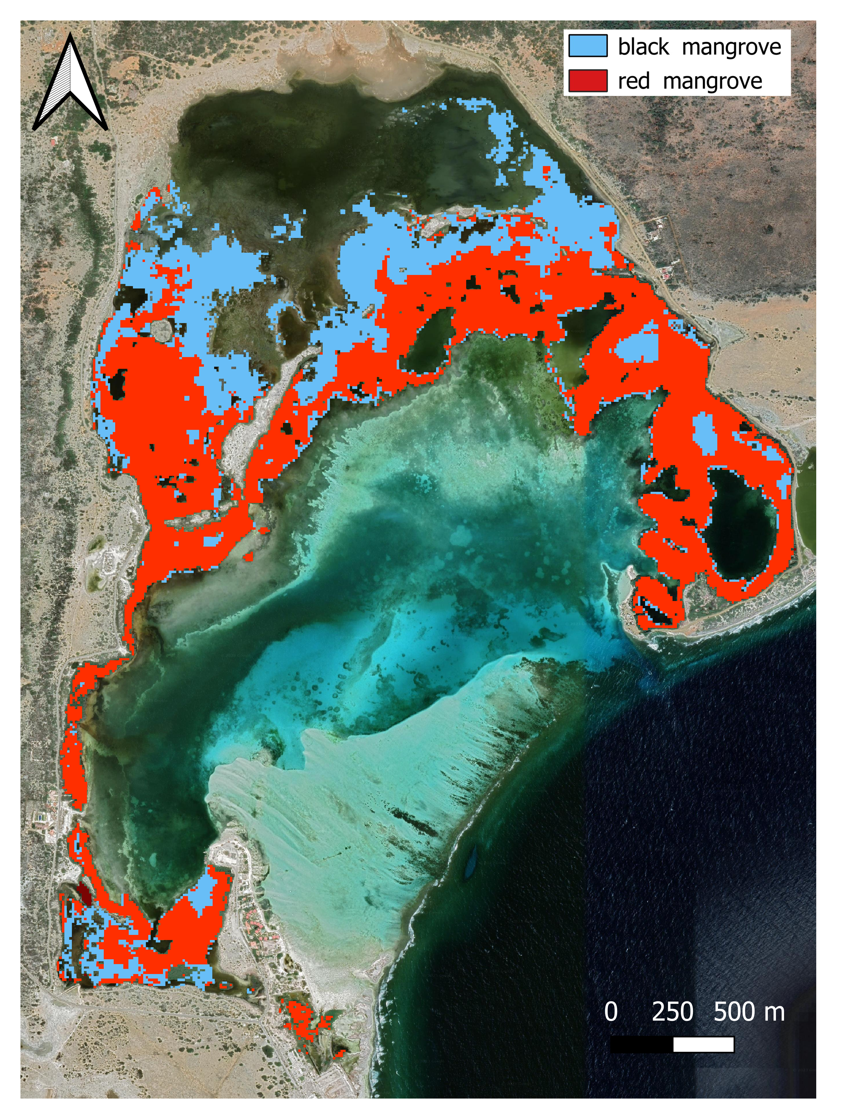
In a recent study, we used Sentinel-2 data to map mangroves on Bonaire, a small tropical island in the Caribbean. Our findings indicate that NDVI (a traditional vegetation index derived from satellite images) can accurately map the extent of the small mangrove forest in Lac Bay, with optimal results achieved during the dry season. We estimated the extent of the mangrove forest in Lac Bay to be 222.3 hectares, with 136.0 hectares attributed to Rhizophora mangle (red mangroves) and 77.1 hectares to Avicennia germinans (black mangroves). A small portion (~ 9 hectares) remains unclassified, likely dominated by Laguncularia racemosa, although on-site validation is necessary for confirmation. Determining mangrove tree species from satellite images is a great achievement, made possible with tailored ground-truthing to train and validate remote sensing algorithms.
Distribution of the black mangrove A. germinans (in blue) and the red mangrove R. mangle (in red) in Lac Bay derived from the Sentinel-2 image registered on 23/03/2022
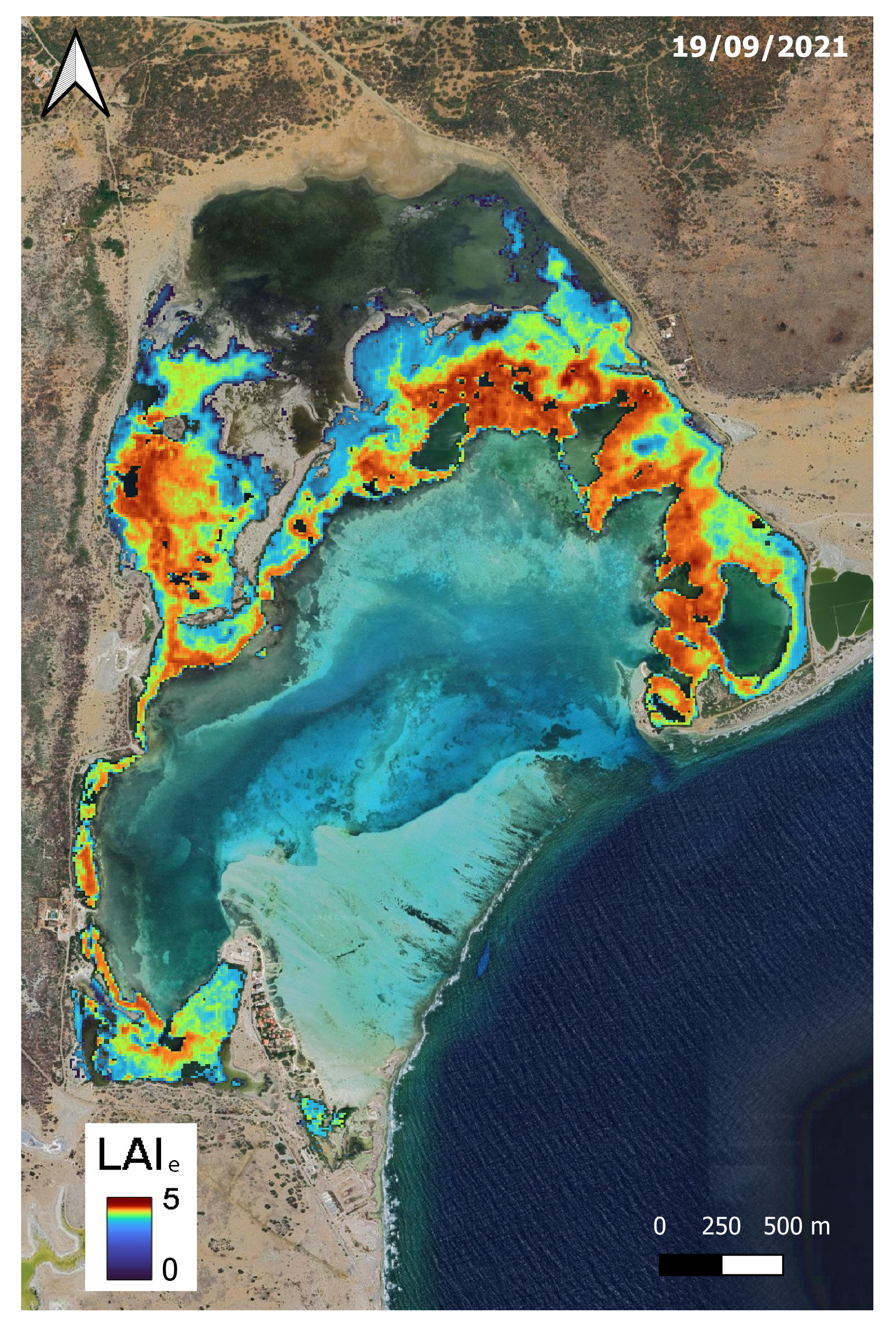
: Maps of estimated LAIe for Lac Bay (Bonaire) for satellite image recorded on 19/09/2021 (dry season).
Furthermore, by measuring on the field the amount of sunlight available above and under the canopy, we were able to derive additional indicators from remote sensing, such as the Leaf Area Index (LAI), an indicator of leaf density, which provides a good insight on the ecological condition of the mangrove and Net Primary Productivity (NPP), an indicator of ecosystem function . The latter corresponds to the difference between the amount of carbon absorbed during photosynthesis and the amount of carbon released during respiration. With a mean NPP rate of 8.82 ± 1.46 gC m-2 d-1, which is equivalent to about 140 tonnes of atmospheric CO2 absorbed per hectare and year, the mangrove forest of Lac Bay in Bonaire absorbs about 26 260 tonnes of CO2 per year. By absorbing the atmospheric carbon, the mangroves of Bonaire contribute to regulate our climate.
In summary, this study offers a practical and affordable way to watch mangroves, not just in Bonaire but potentially on similar small islands facing similar challenges. This kind of monitoring is vital for making informed decisions about how to safeguard these valuable ecosystems, especially in places where resources and expertise are limited. As we are facing climate change, every contribution counts, that’s why we need to monitor closely the state of mangrove forests to be able to address any future changes accordingly, by protective measures, restorative action, or other management measures.